Saturday, September 26, 2009

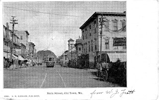
Downtown Old Town Again


I enjoy seeing the changes between postcards and trying to guess what happened. Old Town had many fires so this is probably the major cause.

Another downtown Old Town, Maine postcard


The previous post was from the opposite direction. The one has been colorized (not my favorite technique). We can see the street car as well a horse and wagon. This is looking north toward Indian Island.

44°56'6.24"N
68°38'45.29"W

Friday, September 25, 2009

Very old Old Town, Maine downtown


This is a very old picture of Old Town downtown showing horse and wagons as well as the tracks of the Bangor Street Railway. This section ran from Bangor to Great Works via Main St-Stillwater Ave.-College Ave and more or less Route 2 thru Veazie to Bangor.

This photo is rich in detail showing dirt roads, horses, wagons and a bicycle. Many people can be seen walking on the wide sidewalk.


44°56'8.45"N
68°38'46.66"W

Monday, September 7, 2009

Old Location of St. Joseph Church

I found the answer in an excellent history of St. Joseph Church written by Genie Wollstadt.

She says that it was located in the current Forest Hill Cemetery between the first and second entrance roads. This is the location of the Catholic section, which makes sense.

My parent’s future burial site is about in this location as well as my grandparents.

44°55'14.89"N
68°38'25.75"W

St. Joseph Church Newspaper Article


This explains what happen to the church on Water Street.
I wonder where the location was in Great Works?

Sunday, September 6, 2009

More about Old Town Churches


I found a book with more pictures of Old Town, ME churches. Some are still there and I have added their locations. Some are guesses using old maps.

First Congregation (Demolished) (Star in the East Lodge #60 A.F. & A.M. on this site)
44°56'3.16"N
68°38'53.65"W

First Baptist
44°56'6.37"N
68°38'58.41"W

Methodist Episcopal (Was Demolished) (Old Town Canoe Expansion on site)
44°56'10.83"N
68°38'56.45"W

Universalist Church of Our Father (Was demolished)
44°55'58.26"N
68°38'41.19"W

Chapel Indian Island
44°56'33.75"N
68°39'8.60"W

St. James Episcopal
44°56'4.18"N
68°38'45.49"W

St. Joseph Catholic
44°55'49.14"N
68°38'37.61"W

Union at Stillwater
44°54'36.81"N
68°41'13.41"W

Baptist at Great Works
44°55'2.05"N
68°38'21.40"W